Eons ago, in Forgotten NY terms, that is (OK, maybe 5 years ago) I was sent a cache of color photos of vanished NY scenes. In France, so we hear, they say, “the more things change the more they stay the same”, but as you’ll see in this particular collection…in NYC, the more things change, the more they change even more.
The scenes depicted seem to be from about 1940 through 1960, a time that I find dimly-remembered though not impossibly ancient. There’s just enough familiarity for comfort.
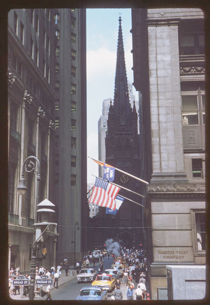
The first image, after all, is iconic: a view down Wall Street to Trinity Church, which has been there since 1846; most of the buildings in the picture are, in fact, still there. What isn’t there anymore is the humungous air-raid siren on the bishop crook lamppost. In those days, if the Russians were coming, we’d have a fairly good idea when they’d get here. Now, our enemies strike without warning.
Regarding the source of these photos, Forgotten Fan Eckart Ruebener writes to say:
The photos on today’s Forgotten NY page were taken by Charles W. Cushman who donated his collection of approximately 14,000 color slides to the University of Indiana. They published the entire collection including Mr. Cushman’s notes on the pictures in their digital library which is accessible under this link.
There are about 160 pictures of various scenes in new York City, mostly lower Manhattan. A fantastic view of Manhattan around 1950!
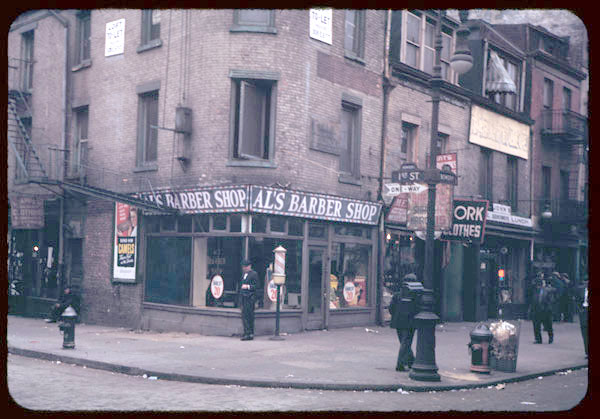
This photo is labelled Bowery and 1st Street, and the time is likely the mid-1940s. In that era the Third Avenue El ran up The Bowery, but for the most part, it left the sidewalks in full sun. 295 Bowery, McGurk’s Suicide Hall, is just out of the picture on the right. This entire block is now dominated by the gleaming Avalon Bowery Place.
Note the lack of an E or W on the 1st Street sign. There’s no West 1st Street; however, modern addresses have this as East 1st and present-day street signs reflect that. This is the first in a sequence of numbered streets in Manhattan and The Bronx that continues north to the Yonkers line. The highest numbered street in the sequence is West 263rd Street in North Riverdale.
Also note that the top of acorn-style glass reflector on the lamppost luminaire is painted black. This was likely in response to World War II air raids. Subsequent luminaire designs forced the light to shine below the post and not diffuse upward.
There’s a barbershop on the corner, followed by a work clothier and then a lunch counter. A second clothing outlet can be seen on 1st Street.
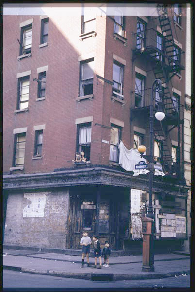
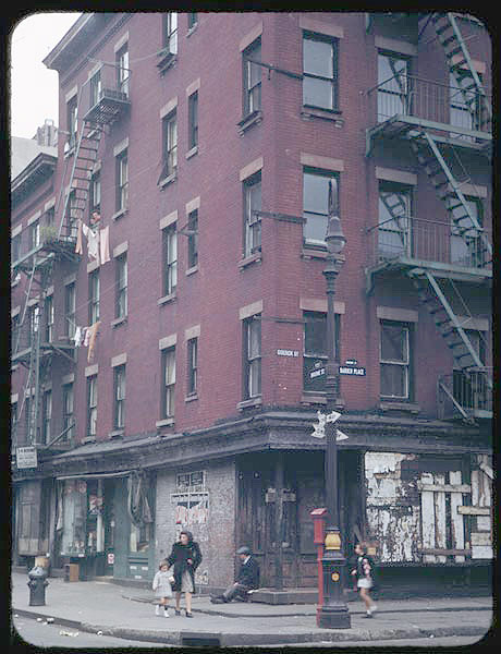
Two views of the vanished corner of Broome Street and Baruch Place on the Lower East Side, and the year can be no earlier than 1939. How do I know that? It’s quite simple. Look very closely at the small blue sign mounted on the corner building on the picture at right, next to the window. The sign says “Goerck Street”, and from Gil Tauber’soldstreets.com we learn that Goerck Street’s name was changed to Baruch Place in 1939. Goerck Street, along with the parallel Mangin Street, honored Casimir Goerck and Joseph Mangin, surveyors who drew up the city’s first overall plan in 1797. In fact they named two out-of-the-way streets for themselves. While the city didn’t adopt the Mangin-Goerck plan, the 1811 Commissioner’s Plan, on which the Manhattan map of today is based, retained their names. Baruch Place honors Simon Baruch (1840-1921), a surgeon responsible for the 1891 institution of the first public baths in the USA.
Most of Baruch Place vanished under housing projects (including the Bernard Baruch Houses, named for Simon’s financier son) between 1944 and 1956. A small piece hangs in there off East Houston Street just west of the FDR Drive. This particular corner is now Corlears Hook Houses.
It’s possible these two photos were taken only days apart. Everything in the two photos is pretty much the same. Or is it? Look again: the bishop crook lampposts are different. The one on the right is a thin Type 6 BC, while the one on the right is a rather thicker Type 24 BC. Apparently the city thought it wise to make a change.
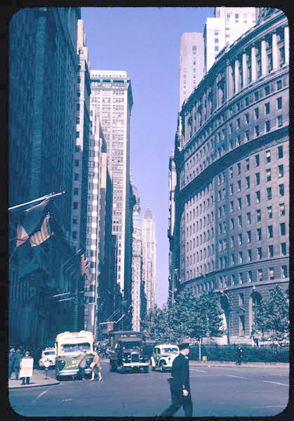
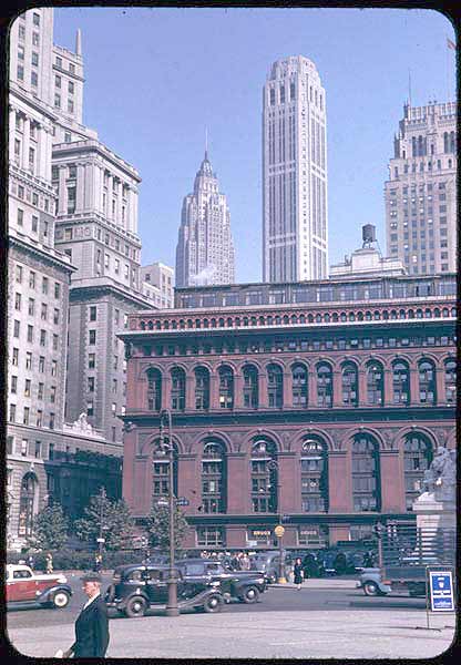
Bowling Green, looking north along Broadway (top) and looking east (bottom). Most of the buildings in the picture at left are still there, with the notable exception of the Singer Tower, seen up Broadway in the background. Designed by Ernest Flagg and completed in 1908, the Singer Tower, at 612 feet, remains the tallest building to be demolished to make way for another building: 1 Liberty Plaza, constructed in 1968.
In the foreground are the International Merchant Marine Building (1882-1884) at left, and at right, curving along Whitehall Street, is the Standard Oil Building (26 Broadway, 1884-1885).
In the photo below is the Romanesque Revival New York Produce Exchange Building, constructed by George B. Post in 1884. It was demolished in 1957 and replaced two years later by 2 Broadway (which is really on Whitehall Street, but it scored this more prestigious address). Obviously, the Produce Exchange was demolished before the modern-day era of preservation arrived in 1964 with the tragic loss of Pennsylvania Station uptown.
In the center background, we see 70 Pine Street, formerly the Cities Service Building, now the American International Building (insurance). It has 66 floors and was completed in 1932 by architect Henry Dougherty, making it a contemporary of the Empire State Building. It was the first skyscraper featuring double-deck elevators. At right is the 54-story 20 Exchange Place, originally the City Bank Farmers Trust Company Building, built by Cross and Cross 1930-31. The entrance features bronze doors are decorated with images of transport vehicles and, if the guards permit, check out domed lobby’s gold-toned floor and marble, mosaics and paintings.

Delancey and Lewis Streets, likely the SE corner. These two streets still actually meet on the Lower East Side, though the Corlears Hook Houses have replaced this particular building. The picture was likely taken from under the Williamsburg Bridge, which looms over the center of Delancey at this point.
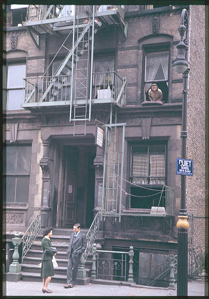
A Type 6 bishop crook lamppost holds a “Quiet” sign in front of a Lower East Side tenement. (One thing I’ve noticed that I hadn’t before from black and white images of the period was that part of the lamposst bases were painted gold for some reason.) I wonder what the sign next to the front door says. People dressed a little more formally then. I’m not sure what to say about that; transport me to that non-air conditioned era, and your webmaster would be a little stifled in the suits and hats I’d have to wear.
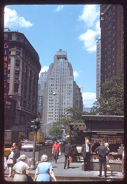
I tend to date NYC pictures by what kind of lampposts appear in them. For example the one at left can be no earlier than 1950, since that’s the year that our now-familiar aluminum 8-sided poles first appeared. We’re in Greeley Square, 6th Avenue (oops, Avenue of the Americas) at West 32nd Street, looking up the street at the office tower that replaced the New York Herald Building. Its bellringers, Stuff and Guff, and Minerva were removed and placed in Herald Square, where the bellringers still strike the midday hours.
At left is the 1901 Saks & Company Building, later clad in impenetrable black in 1982 as many fashionable NYC women are. Gimbels, on the immediate left just out of the photo, was remodeled as the Manhattan Mall in 1988. (When your webmaster worked in the area, I savored my lunchtimes in the 7th-floor food court. At length, it was decided that the 7th-floor view was too good for area workers, the 7th floor was converted to offices, and the food court went to the basement.)
The newsstand is still there.
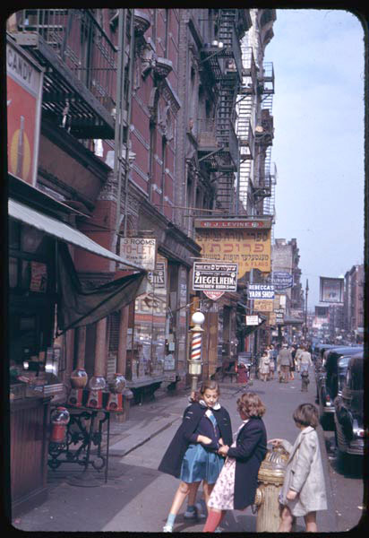
This photo is identified simply as being on the Lower East Side. It looks Broadway-ish to me though it could be East Broadway or even the Bowery. The signs use Hebrew characters, though the language may be in Yiddish. I’d bet the sign suspended over the street is a campaign ad.
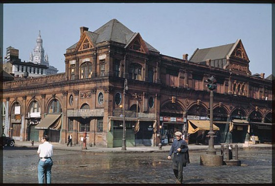
The old 1883 Fulton Market building, NW corner, South and Fulton Streets ca. 1940. This building was razed in 1948. The present 1983 Fulton Market Building, which echoes this building somewhat, is in its place today.
Even if the building remained in its present form, a photo like this is impossible to take today, since the Franklin D. Roosevelt Drive was decked over South Street in 1942.
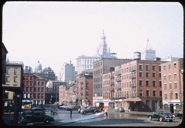
South Street and Peck Slip, with the Municipal Building looming in the rear.
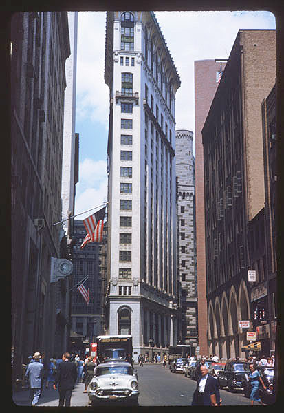
#1 Liberty Street, at Maiden Lane, was constructed in 1907 along one of the odd building plots in lower Manhattan that make it so interesting. The terra cotta tile at the top projected a full 12 feet outward. Louise Nevelson Plaza today occupies this site, featuring the artist’s sculptures. In the background we see the 1924 Reserve Bank of New York, our own Fort Knox, or rather, the Fort Knox of the world, since gold from many nations is stored five levels below the building.
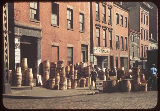
Pearl Street, and a whole lot of barrels. The Second and Third Avenue els came together at Chatham Square and ran south along Pearl Street to South Ferry.

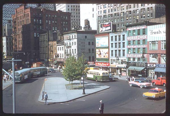
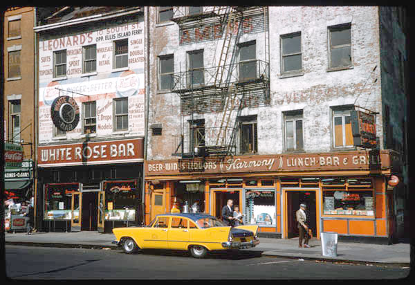
3 views of Peter Minuit Plaza, at State, Whitehall and South Streets. These 1960 views were likely taken from the old South Ferry building; it burned down in the 1990s and was replaced by a gleaming new glass terminal in 2005. This was thought to be the site where Peter Minuit, Director General of the New Netherland colony from 1626-1633, purchased Manhattan Island from native Americans. Further scholarship has determined that the exchange took place further north, where Inwood Hill Park is now.
All these buildings have been wiped off the map, with the exception of the large brownstone building at left. This is the 1886 US Army Building. For what used to go on there, we’ll let Arlo Guthrie explain it for you:
“They got a building down New York City, it’s called Whitehall Street, where you walk in, you get injected, inspected, detected, infected, neglected and selected. I went down to get my physical examination one day, and I walked in, I sat down, got good and drunk the night before, so I looked and felt my best when I went in that morning. `Cause I wanted to look like the all-American kid from New York City, man I wanted, I wanted to feel like the all-, I wanted to be the all American kid from New York, and I walked in, sat down, I was hung down, brung down, hung up, and all kinds o’ mean nasty ugly things. And I waked in and sat down and they gave me a piece of paper, said, “Kid, see the psychiatrist, room 604.”
And I went up there, I said, “Shrink, I want to kill. I mean, I wanna, I wanna kill. Kill. I wanna, I wanna see, I wanna see blood and gore and guts and veins in my teeth. Eat dead burnt bodies. I mean kill, Kill, KILL, KILL.” And I started jumpin up and down yelling, “KILL, KILL,” and he started jumpin up and down with me and we was both jumping up and down yelling, “KILL, KILL.” And the seargant came over, pinned a medal on me, sent me down the hall, said, “You’re our boy.” Alice’s Restaurant
The US Army building received a green glass cladding in 1986.
2nd/3rd photos: The Horse Shoe Bar, The White Rose Bar and Harmony Cafe, at Whitehall and Front Streets, had been banished by 1969, replaced by #3 New York Plaza. Even Front Street vanished. There was no shortage of libations at South Ferry in the fab Fifties, that’s for sure.
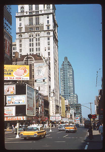
Looking west on West 42nd Street from Broadway. The biggest building at left is the 1914 Candler Building, built for early Coca-Cola executive and the mayor of Atlanta from 1916-1919, Asa Griggs Candler. This building has seen West 42nd in its heyday as NYC’s entertainment mecca, devolve into Forty-Deuce, and revive yet again to the tourist magnet it is today.
When The New York Times moved to the Times Tower, just out of the picture on the right, on December 31, 1904 it marked the occasion with fireworks…which have exploded here every December 31 since. It is the staging area for the famed lighted ball that drops at midnight.
Looming in the rear is the Art Deco/Art Moderne McGraw Hill Building, completed in 1931 by Raymond Hood and Godley & Fouilhoux. Critics poked fun of the aqua coloring when it was built, but most experts now consider it a masterwork.
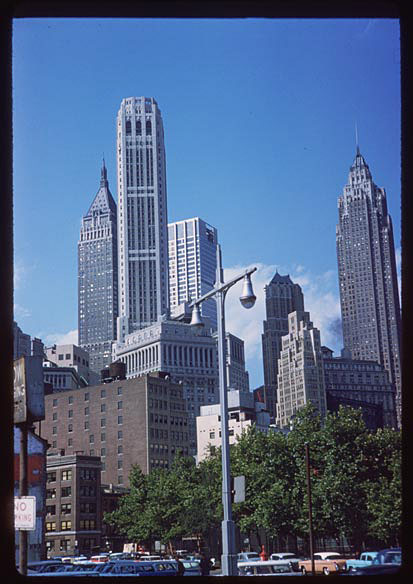
A view from South Street near Minuit Plaza. These tall towers (see above) have been joined by other buildings of comparable height, so they don’t stand out as they once did.South Street at one time had a flock of Triborough Bridge style lampposts. Some of them hung in there until around 1980.


